“Using a laser scanner ensures a well-founded design basis and promotes a great start on you project”
Laser scanning
Whether you’re designing a modification to a complex refinery piping system, surveying a site or documenting a historic building, laser scanning is a fast and effective method to collect data for your design basis. Laser scanning establishes a point cloud with millimeter precision which provides a full photographic color reproduction in 3D. Laser scanning provides a flexible basis for further modeling and visualization.
By choosing LIFA as your supplier for laser scanning data you will be a part of a team with experience and knowledge about solving a given task the best and most cost-effective way. We already have a great expertise in using traditional surveying equipment and laser scanning works perfectly in combination with that.
The following list contains a selection of former laser scanning jobs:
- Surveying a building and technical installations
- Measuring facades
- Measurement of piping, tanks etc.
- Complete 3D model of a ship
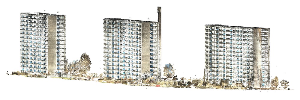
Surveying a building
In general the result from using a laser scanner for a building survey is a 3D model. The model is used as a design basis for an extension or a conversion of a building. The laser scanner registers every small and complex detail on a building which is why it is such an accurate and complete method for surveying buildings.
An example: A customer has a series of complex light wells that needs new cladding. By laser scanning the light wells we were able to model the scans with an accuracy that made it possible for the costumer to order the cladding with the exact measurements. Upon installation they all fitted perfectly. Laser scanning the light wells saved the costumer money in wasted cladding. [Rosengårdcentret in Odense]

Measurement of piping
An example: A refinery is renovating a complex piping system. Laser scanning is used to produce the best possible design basis. The entire system is scanned including the foundation and a complete 3D model is processed and delivered to the customer. The 3D model made it possible for the refinery to renovate the piping system, without any unexpected problems due to lack of space around and under the piping system. [Shell Refinery in Fredericia]
Measuring facades
When laser scanning a facade we achieve a complete survey with a point density that makes it possible to document every little bump on the surface.
An example: A violent storm made damages on a large facade on a building. To document the extent of the damage the building was scanned. Laser scanning is a fast method to collect this kind of data. In this case there was a limited need for data processing which meant, that the customer received the data the same day as the scan took place. The quick way this job was done made it possible for the costumer to take the necessary precautions to start securing and repairing the facade. [Carlsberg Denmark]

Complete 3D model of a ship
Laser scanning can also be useful when rebuilding a ship. It is possible to scan a ship both offshore and in dock.
An example: A costumer was given the task to lengthen an already fully functional ship. By laser scanning the ship on the inside as well as on the outside we were able to generate precise profiles from the 3D model at the exact locations where the ship would be cut. The new part of the ship was produced also by using the 3D model as a design basis.
Facts about laser scanning
Today we divide laser scanning into two methods – terrestrial laser scanning and the mobile slam laser scanning.
Terrestrial laser scanning
The laser scanner is placed on a tripod and when the scan is done it is moved to the next position and so on until everything is scanned. This method of scanning gives a high accuracy in datasets and the possibility of photographic reproduction.
Mobile slam
The mobile slam laser scanning has a lower quality in accuracy compared to the terrestrial laser scanning but it compensates in speed. It is fast method because you don’t need the tripod – you only need to walk through all the rooms/areas you want to scan with the slammer in your hand. This method is excellent for drawing up floor plans and measuring square meters within a building.
3D modeling
The use of laser scanning for creating 3D models results in a truer model of the object than with traditional land surveying. The reason for this is the high density of the point cloud. We collect more data with laser scanning. Another reason for using laser scanning is the completeness, the laser scanner sees all within its line of sight, it is not a choice made by the person behind the instrument whether or not the object is relevant.
The final product from the laser scanning and the modeling is a result of LIFA working close together with the costumer in clarifying what they need. It is important that the customer receives a model containing the wanted level of detailing. Too much information might confuse the purpose of the model and too little information might not give the answers that were needed.